WWLLN
World Wide Lightning Location Network
Latest WWLLN world lightning map
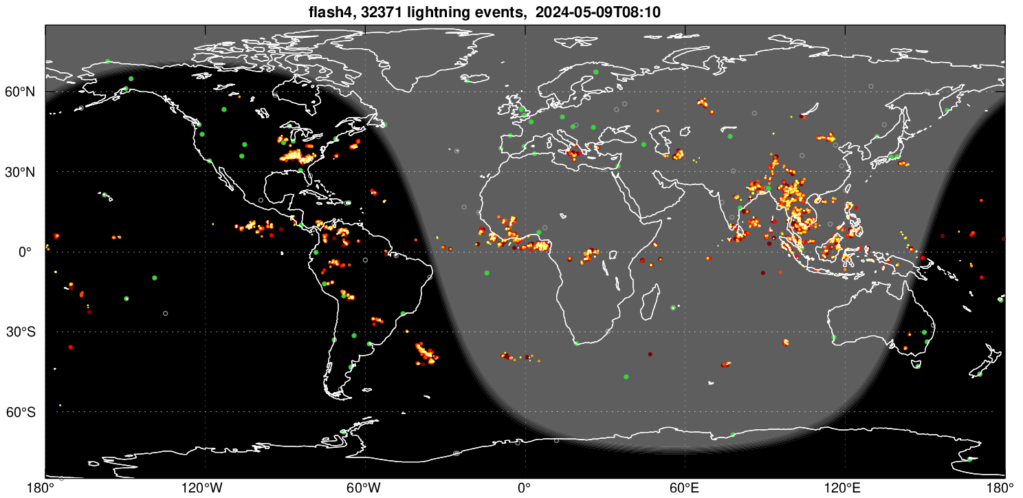
Lightning stroke positions detected over the previous hour are shown. White markers indicate lightning occurring within the last 10 minutes, then yellow, orange, orange red, red, and maroon markers show activity occuring 20, 30, 40, 50 and 60 minutes ago respectively. Green markers indicate active WWLLN lightning sensors.
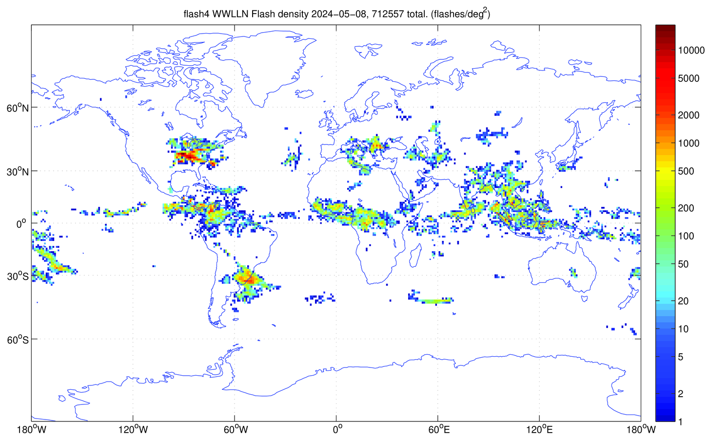
Daily WWLLN flash density map
A WWLLN lightning flash density map is generated shortly after midnight UTC each day. This map contains all WWLLN data from the previous day.
About WWLLN
The World Wide Lightning Location Network (WWLLN - pronounced 'woollen'), is a network of very low frequency (VLF) radio lightning sensors operated by the University of Washington in Seattle. Most ground-based observations in the 3 - 30 kHz VLF band are dominated by impulsive signals from lightning discharges called “sferics”. Significant radiated electromagnetic power exists from a few hertz to several hundred megahertz, with the bulk of the energy radiated at VLF. With our world wide network of lightning sensors, we are producing regular maps of lightning activity over the entire Earth.
How it works
We welcome offers of hosting a new WWLLN lightning sensor. All hosts receive all the world-wide data for their own research. In return, each host provides the computer and meets any local expenses like power, Internet, and maintenance. However, do not think that a sensor on your own campus is going to give you lightning location data on its own. Only the whole network does that.
Each lightning stroke location requires the time of group arrival (TOGA) from a least 5 WWLLN sensors. These sensors may be several thousand km distant from the stroke. The geographical arrangement of the sensors is important: a lightning stroke which is enclosed by sensors is much more accurately located than one which is not so enclosed. Clearly a uniform spacing of sensors around the Earth is the ideal. Since the Earth is round, there are no edges: every lightning stroke is surrounded by sensors, but not necessarily by the sensors which sense it. Typically only about 15 to 30% of strokes detected by one sensor are detected by 5 or more. These strokes are usually the stronger ones. Recent research indicates our detection efficiency for strokes about 30 kA is approximately 30% globally.
To cover the whole world by sensors spaced uniformly about 1000 km apart would require roughly 500 sensors. If spaced 3000 km apart, we would need “only” around 50 to 60 sensors. Presently we have over 70 WWLLN sensors. We are always on the look out for more sensor sites.
Please contact us if you are interested in hosting a WWLLN lightning sensor.
Publications
More information on the World Wide Lightning Location Network is available from our publication list.
WWLLN Data Available
Archival data are available for sale from August 15, 2004 to the present. Our site hosts receive a free monthly subscription. WWLLN Data are available via internet with cadence every 10 minutes for research purposes from the University of Washington, or with a cadence of as fast as every minute (i.e. in realtime) from our commercial reseller. Please contact us for more information.
Acknowledgements
WWLLN data is produced with the help and cooperation of numerous universities, institutes and researchers located all around the world. Many thanks to these groups for hosting our WWLLN lightning sensors!